

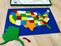
Just acquired what is basically my Rosebud-equivalent childhood toy: a vintage Lauri “Fit-A-State” foam rubber puzzle map, complete with the laziest Hawaii ever! It’s truly the map that made me. Shocking, I know. Aside from a few missing pieces (Canada and Mexico) and alternate colors, it’s exactly as I remember.
I’d originally sought out this Lauri map as part of research I was doing for a potential essay entry in Citylab’s “The Map That Made Me” series. I fired off a prompt, but sadly it wasn’t accepted, and I let it sit unfinished. Here’s that prompt in all its incomplete glory:
Puzzle maps are time-honored educational tools that teach much more than basic geography. They’re the gateway to social, cultural, creative, and scientific fields of study.
Party tricks are fun. They’re great icebreakers for the shy and sociable alike, and many people have several at their command. I only have one, and it’s not even unique, but my friends and family consider it a non-trivial superpower: I can scrawl out a United States map, quickly and from memory, at the drop of a hat.
My ego loves the choruses of “Amazing! Incredible!” that follow when I do this, but like many nascent megalomaniacs, I owe it all to an overactive imagination and a particular childhood toy. This long-lost Rosebud-equivalent artifact was a Lauri “Fit-A-State” foam rubber puzzle map I was gifted as a very young child. I can trace everything about my love of maps to that rubber puzzle—place, history, culture, narrative—as well as my first exposure to critical skills I use every day as a designer: color, shape, layout, and problem-solving.
Puzzle maps are, of course, common and venerable educational tools. I found several “vintage” Lauri puzzles on eBay, similar to (but not exactly like) the puzzle I had as a child, but I still had to wade through a sea of USA map puzzle search results. American schoolchildren have been piecing together these maps for generations—19th-century educators were using early jigsaw “dissected maps” to teach geography—but the concept of maps as educational games goes back to 1700s Europe, and puzzles in general back to Archimedes.
At age six, I only knew Archimedes was some guy who could never finish a bath. My USA puzzle map was a far more compelling totem-like treasure of family history. There’s California (in blue), my home. There’s Michigan (in white), where my mother’s parents raised her beneath the bright lights of Wolverine football. There’s New Mexico (also in white), where my aunt and uncle would soon move after leaving L.A. There’s Illinois (in yellow), the exotic locale from which Harry Caray and my beloved-yet-doomed 1984 Chicago Cubs were beamed in via WGN. The puzzle map’s colors and shapes burned that personal history into my young brain.
Much later, I’d learn that this was related to my own synesthesia. My mind associates numbers, letters, musical keys, and days of the week with colors (perhaps thanks to multicolored refrigerator magnets)—and the states’ shapes were no different. I’ll always visualize California as blue, Texas as green, Missouri as orange, Montana as red, and so on. This may prove annoying when I get my hands on one of those eBay puzzles—none of which had the “correct” colors as I remember them! That synesthesiac pattern continued as a tween and teen, when I discovered the detailed street maps of Thomas Guides and would forever remember various Southern California cities by their Guide colors: Santa Monica (pink), Malibu (purple), Glendora (green), Anaheim (orange), Riverside (white).